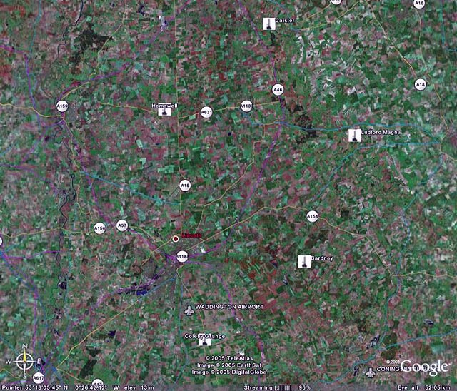
The Hemswell group
The topography of Lincolnshire being flat necessitated the use of triangulation stations on elevated positions.
Lincoln Cathedral was one of those used. The climb was up a
narrow spiral stone staircase which prevented the use of back packs, I forget
the actual number of steps but am sure that it was in excess of 200. The
theodolites , lamps and batteries had to be carried up in ones arms. I spent
many hours on the top light keeping.
Details from OS Lincoln - SK9771 - On the roof of the Central Tower, where
the nave meets the transepts.
Other elevated trigs were on Church towers and water towers. Water towers required the surveyor to climb up a ladder usually under the tank, along a walkway and finally up a ladder on the outside of the tank. The tops were curved surfaces which required great care by the surveyor.
On the sites themselves it was often necessary to build a Bilby Tower which could be constructed to a maximum of 105 feet. These towers comprised two unconnected towers one inside the other. The inner tower was to carry the instruments and the outside one the observing party. When light keeping it was also necessary to carry the lead acid batteries to the top. We did try using long electrical cable but the voltage drop was too great to produce enough light at the lamp. Initial instruction on building these towers was given by a party from the Ordnance Survey at RAF Hemswell.
Lincoln cathedral
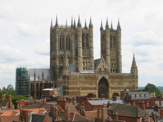
Reproduced with the kind permission of Jonathan Rawle.
Thanks to the ORDNANCE SURVEY, I have photographs of the top of Lincoln Cathedral & Bilby Towers.
To view the thumbnails below, click on the thumbnail, to return click back button in IE
|
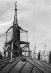
Geodetic Tavistock on top of Lincoln Minster (Corporal Griffiths)
©Crown copyright Ordnance Survey Published with thanks to and the permission of Ordnance Survey
|
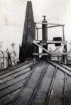
Geodetic Tavistock on top of Lincoln Minster
©Crown copyright Ordnance Survey Published with thanks to and the permission of Ordnance Survey
|
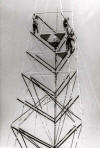
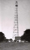
Photographs of Bilby Towers under construction & completed
The Completed Tower is 103ft high, we never need the full height and most were either 30ft or 60ft
We were trained in the construction of these towers by the Ordnance Survey
|
The 1st section of both the outer & inner towers completed over a pillar The buried ends are fixed to railway sleepers
©Crown copyright Ordnance Survey Published with thanks to and the permission of Ordnance Survey |
Bilby Tower construction, nearing completion
©Crown copyright Ordnance Survey Published with thanks to and the permission of Ordnance Survey |
|
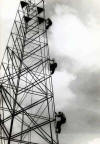
Climbing the tower
©Crown copyright Ordnance Survey Published with thanks to and the permission of Ordnance Survey |
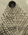
Looking up the completed tower
©Crown copyright Ordnance Survey Published with thanks to and the permission of Ordnance Survey |
|
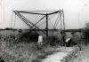
A distant view of the completed tower
©Crown copyright Ordnance Survey Published with thanks to and the permission of Ordnance Survey |
|
RAF Hemswell -No 97(SM) Squadron RAF 3 Thor IRBM launchers - Dec 1, 1959 - May 24, 1963.
|
RAF Ludford Magna -No 104(SM) Squadron RAF 3 Thor IRBM launchers-Jul 22, 1959 - May 24, 1963.
|
|
RAF Bardney -No 106(SM) Squadron RAF 3 Thor IRBM launchers - Jul 22, 1959 - May 24, 1963
|
RAF Coleby Grange - No 142(SM) Squadron RAF 3 Thor IRBM launchers - Jul 22, 1959 - May 24,
|
|
RAF Caistor -No 269(SM) Squadron RAF 3 Thor IRBM launchers - Jul 22, 1959 - May 24, 1963
|